
Description
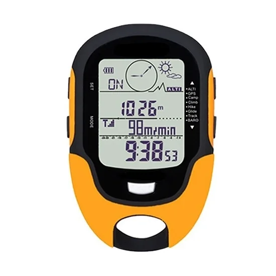
Multifunctional electronic compass and altimeter is used for hiking, mountaineering adventures, and outings. It provides you with accurate direction guidance, altitude, temperature, weather and other real-time data to ensure that you can keep track of your travel status at any time.
Features
- Multifunctional electronic compass and altimeter adopts acrylic LED display, equipped with acrylic surface and ABS shell material, with good gloss and exquisite appearance.
- The multifunctional electronic compass and altimeter supports GPS and Beidou dual-core positioning, provides 9 sets of target point tracking, latitude and longitude display, target point direction, distance, return speed and return time.
- It has practical altitude change warning function, including altitude change warning and target altitude warning.
- The electronic altimeter has a flashlight function, which is suitable for outdoor camping, camp lighting, fishing night light and daily outdoor lighting needs.
- The digital compass and altimeter have IPX4 waterproof function and can resist water droplets splashing in any direction.
- It is equipped with an altitude data recorder that can record altitude, climbing altitude, 7 days and 24 hours altitude curve chart, altitude gain, altitude loss and target altitude warning (suitable for parachuting).
Specification
- Model: ATO-FR510A
- Working temperature: -20℃~+60℃/-4℉~+140℉
- Storage temperature: -30℃~+60℃/-22℉~+140℉
- Altimeter display range: -500m~9000m (-1640ft~32760ft)
- Altimeter resolution: 1m/3ft
- Barometer display range: 300~1100hpa (8.8~32.60inHg)
- Barometer resolution: 0.1hpa/0.03inHg
- Thermometer resolution: 1℃/1℉
- Compass resolution: 1°
- Humidity measurement range: 20%~95%
- Satellite: GPS/Beidou dual satellite system compatible
- Waterproof level: IPX4
- Material: ABS
- Certification: CE
- Size: 100x66x20mm
- Weight: about 71g
Dimension (mm)
Operation Introduction
Tips: Application of multi-function electronic compass and altimeter
- Mountaineering and hiking: Provide accurate navigation, altitude and return information to prevent getting lost and monitor altitude changes to ensure safety.
- Camping and wilderness survival: Equipped with flashlight function, provide orientation and weather monitoring, adapt to humid environment, and ensure night activities.
- Fishing: Provide accurate positioning and weather data to help choose the best time and place for fishing.
- Navigation and water activities: Through GPS and Beidou dual-core positioning, provide direction guidance to ensure the safety of water activities.
- Skydiving and air sports: The altitude warning function monitors the skydiving altitude in real time to ensure a safe landing.
- Field exploration and rescue: Provide accurate positioning and target tracking to help rescuers find the target quickly.
Reviews
There are no reviews yet.